Welcome to WordPress.com. This is your first post. Edit or delete it and start blogging!
Halloween

JJ Meehan
jjmeehan13@hotmail.com
WEB Site
http://themeehanfamily.com/
Contributor
Michele Kerrigan
In addition to Michele Kerrigan, information on this page is from http://en.wikipedia.org/wiki/Halloween. Halloween started in Ireland over 2000 years ago. During the famine time the Irish as you emmigrate to lands such as America and brought with them their traditions hence we now have Halloween celebrated in the US and other European countries.
Historian Nicholas Rogers, exploring the origins of Halloween, notes that while “some folklorists have detected its origins in the Roman feast of Pomona, the goddess of fruits and seeds, or in the festival of the dead called Parentalia, it is more typically linked to the Celtic festival to honor the dead and of harvest, it has been reincarnated many times over the centuries into our modern celebration. of Samhain, whose original spelling was Samuin (pronounced sow-an or sow-in)”. The name is derived from Old Irish and means roughly “summer’s end”. A similar festival was held by the ancient Britons and is known as Calan Gaeaf (pronounced Kálan Gái av).
The ancient Celts believed that the border between this world and the Otherworld became thin on Samhain, allowing spirits (both harmless and harmful) to pass through. The family’s ancestors were honoured and invited home while harmful spirits were warded off. It is believed that the need to ward off harmful spirits led to the wearing of costumes and masks. Their purpose was to disguise oneself as a harmful spirit and thus avoid harm. In Scotland the spirits were impersonated by young men dressed in white with masked, veiled or blackened faces. Samhain was also a time to take stock of food supplies and slaughter livestock for winter stores. Bonfires played a large part in the festivities. All other fires were doused and each home lit their hearth from the bonfire. The bones of slaughtered livestock were cast into its flames.[6] Sometimes two bonfires would be built side-by-side, and people and their livestock would walk between them as a cleansing ritual. The Celts lived long before recorded history – for them it was the holiest day of the year and the start of the New Year. When Ireland was converted to Christianity the priests continued to allow the Irish to celebrate their festival for a few hundred years, then it was banned – but the Irish continued to celebrate it in secret.
The Catholic Church demonized everything about the old religions – which is why Halloween is considered evil. The Catholic Church also created “All Saints Day” also known as “All Hallows Day” on November First, and “All Souls Day” on November Second, to let the Celts continue to honor parted souls in a “Christian way”
The night before All Hallows Day was known as All Hallows Eve (just like Christmas Eve).

When Europeans first came to America there was no Halloween. When the Irish came to America during the potato famine they brought their festival with them. And Americans translated the customs into what they wanted them to be. (For example, A Jack ‘O Lantern used to be made out of a turnip). The Early 1900’s first saw what we would recognize as Halloween, but it was seen as an Adult Holiday, with children being allowed to participate. Halloween was cancelled during WWII. After WWII Halloween became the fun and festive holiday that we have today, with it being more oriented to children.
You can see all of our blogs on our WEB Site for IRELAND at http://themeehanfamily.com/blogs/ireland.htm
If you are interested in helping me with blogs on Ireland please contact me at jjmeehan13@hotmail.com.
The following is an Irish Blessing:
Posted in Ireland
Leave a comment
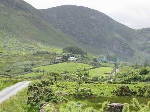
County Kerry, Ireland – Part II

JJ Meehan
jjmeehan13@hotmail.com
WEB Site
http://themeehanfamily.com/
Contributor
Michele Kerrigan
Ireland is “God’s Country” and County Kerry maybe the gem of all Ireland. On May 8th, 1860 my great grandfather John O’Connor married Mary O’Connor in Cascade Iowa. Father Jeremiah O’Connor was the Priest who celebrated the wedding Mass. None of them were related. John O’Connor was the son of Jeremiah O’Connor and Eleanor Grady. Mary was the daughter of Thomas O’Connor and Bridget Quirk. All were from County Kerry, Ireland. Until he died in 1903, John O’Connor considered Ireland God’s County and he as did most the Irish emigrates had a deep desire to return to his native land. On his grave stone he entered “A NATIVE OF BALLY-NA-BUNK A SUB-DIVISION OF MOORESTOWN, PARISH OF DINGLE, CO. KERRY, IRELAND.”

County Kerry and Ireland was his dream and both are now my dream and this blog is written in honor of John and Mary O’Connor and all the other good folks in Ireland and who have emigrated from Ireland. You can view the John and Mary Family Tree at http://themeehanfamily.com/oconnor/index.htm. The following blog will try to capture the beauty of Ireland via pictures and video’s from folks who have visited this jewel of a land and will have information from several sources on the history of the area. These sources include; Wikipedia on County Kerry, Ancient History of County Kerry and Ancient Kerry (Rootsweb).
Conor (Connor) Pass
Conor Pass is near the home of my great grandmother, Mary O’Connor – Village of Camp which you will pass through on the way to the mountain.

The Conor Pass is the highest mountain pass in Ireland. It is situated on the Dingle Peninsula in County Kerry, on the road that crosses the peninsula between Dingle Town and the coast the other side. The Mountains the Pass crosses are the Brandon Mountains and contain Ireland’s second highest peak Brandon Mountain at 3127 ft. From Dingle Town the road runs some 4½ miles rising to 1500 ft as it winds its way to the pass. There are wonderful views of the coast. At the Pass there is a carpark where you are confronted with this magnificent sight. The road then carries on down towards Brandon Bay past cliffs, a waterfall and lakes.
 |
 |
 |
 |
The route from Blennerville passes for a time along the north coast of the Peninsula, with some fine views down to the sea. Follow the road on through the village of Camp and past the turning for Castlegregory, when the road will turn south and head across the mountains through the spectacular Conor Pass, with views of Tralee Bay to the north and Dingle Bay to the south.
 |
 |
 |
 |
Conor Pass is one of the scenic highlights on Dingle Island and makes a great place for an excursion from Killarney. The narrow mountain-road is going from Dingle town to the northern part of the peninsula – the panorama is simply overwhelming…The road over Connor Pass is restricted to cars with less than 3,5 tons – the street is a one-way-track with several passing places – the rocks hang over at some places and might scratch or damage your motor home…
Lake Killarney
With its three famous lakes and great mountain ranges, Killarney in County Kerry Ireland has been the inspiration of poets and painters over many centuries. The Killarney National Park is internationally renowned both for its scenic beauty and scientific interest. Added to the beauty of the three main lakes are many other lakes in the folds of the mountains, numerous picturesque cascades and, rising to the west of the valley, the peaks of MacGillicuddy’s Reeks. There are many walks and trails around Killarney ranging from a two hour tourist trail around the town itself to the 215km (135 miles) long distance walking route (“The Kerry Way”) from Killarney around the Ring of Kerry.
 |
 |
TORC WATERFALL Visitors can enjoy various day trips around the area. The Gap of Dunloe Tour is highly recommended and discovers Killarney at its mystical best, Torc Waterfall is one of the finest waterfalls in Ireland and Ladies View offers some of the most spectacular views of the Killarney valley. Visitors without their own transport can travel in the traditional jaunting-cars, water buses or in modern coaches around the area.
Muckross House
Muckross House (Irish: Theach Mhucrois) is located on the small Muckross Peninsula between Muckross Lake and Lough Leane, two of the lakes of Killarney, 6 kilometers (4 mi) from the town of Killarney in County Kerry, Ireland.
Muckross House is a mansion designed by the Scottish architect, William Burn, that was built in 1843 for Henry Arthur Herbert and his wife, the watercolourist Mary Balfour Herbert. With sixty-five rooms, it was built in the Tudor style. Extensive improvements were undertaken in the 1850s in preparation for the visit of Queen Victoria in 1861. It is said that these improvements for the Queen’s visit were a contributory factor in the financial difficulties suffered by the Herbert family which resulted in the sale of the estate. In 1899 it was bought by Arthur Guinness, 1st Baron Ardilaun who wanted to preserve the dramatic landscape.
 |
 |
Killarney National Park was formed principally from a donation of Muckross Estate, which was presented to the state in 1932 by Senator Arthur Vincent and his parents-in-law Mr. and Mrs. William Bowers Bourn II, in memory of Senator Vincent’s late wife, Maud. The park was substantially expanded by acquisition of land from the former Earl of Kenmare’s estate.

The house, gardens and traditional farms are all open to the public with guided tours of the house’s rooms.
Muckross Abbey
Muckross Abbey is one of the major ecclesiastical sites found in the Killarney National Park, County Kerry, Republic of Ireland. It was founded in 1448 as a Franciscan friary for the Observantine Franciscans by Donald McCarthy More.

It has had a violent history and has been damaged and reconstructed many times. The friars were often persecuted and subjected to raids by marauding groups. Today the abbey is largely roofless although, apart from this, is generally quite well preserved. Its most striking feature is a central courtyard, which contains a large yew tree and is surrounded by a vaulted cloister.

Ground plan of Muckross Abbey
In the 17th and 18th centuries, it became the burial place for prominent County Kerry poets O’Donoghue, O’Rathaille and O’Suilleabhain.
Gallarus Oratory
The Gallarus Oratory (Irish: Séipéilín Ghallarais, literally “The Church of the Place of the Foreigners”) is believed to be an early Christian church located on the Dingle Peninsula, County Kerry, Ireland. Though the building is believed to have been built between the 6th century and 9th century, some believe it could have been built as late as the 12th century because the east window has a rounded top made of two carved stones (not a true arch). According to local legend, if a person climbs out of the oratory via the window, their soul will be cleansed.
 |
 |
As early as the 6th century, monastic settlements were being built in remote areas of Ireland. This small oratory, built without mortar, uses corbel vaulting, a technique developed by Neolithic tomb-makers. It is dimly lit, with only a tiny window opposite the entrance door. Shaped like an upturned boat, this miniature church overlooks the harbour at Ard na Caithne (formerly also called Smerwick) on the Dingle Peninsula.
It is a corbelled-roofed building, built with the stones being laid at a slight angle, lower on the outside than on the inside, thus allowing rainwater to run off. This design has kept the interior relatively dry despite the lack of mortaring, allowing the building to remain in excellent condition.

Kerry was predominantly a Catholic county. More than 155,000 people in the county were Catholic: this equated to more than 95% of the population. There were small Church of Ireland (Frederick Barton, a handyman in Fenit), Methodist (George Forde, a clergyman in Killarney) Presbyterian (Neil Brownlee, a Presbyterian customs officer in Fenit), Plymouth Brethren (John Brennan in Kenmare) and Jewish communities, but the institutions of the Catholic church were visible in every corner of Kerry (see Convent of Mercy in Tralee). So too were its mores (see interesting return for Katie Joy from Listowel). The Bishop of Kerrry was domiciled at St. Brendan’s Cathedral in Killarney, from where he oversaw a network of parishes (Fr Timothy Griffen was the parish priest in Ballyferriter). There were also various religious orders based in the county. The Dominicans had a house in Tralee and the Franciscans established a house in Killarney. For more information please visit http://www.census.nationalarchives.ie/exhibition/kerry/government_politics_institutions.html.
You can see all of our blogs on our WEB Site for IRELAND at http://themeehanfamily.com/blogs/ireland.htm
If you are interested in helping me with blogs on Ireland please contact me at mfmeehan@live.com.
The following is an Irish Blessing:
Posted in Ireland
Leave a comment
County Kerry, Ireland – Part I

JJ Meehan
jjmeehan13@hotmail.com
WEB Site
http://themeehanfamily.com/
Contributors
Donna McCormick
Michele Kerrigan
This is Part I of II. Part II is located at http://jjmeehan.spaces.live.com/blog/cns!5545F38A4B977846!9229.entry.
Ireland is “God’s Country” and County Kerry maybe the gem of all Ireland. On May 8th, 1860 my great grandfather John O’Connor married Mary O’Connor in Cascade Iowa. Father Jeremiah O’Connor was the Priest who celebrated the wedding Mass. None of them were related. John O’Connor was the son of Jeremiah O’Connor and Eleanor Grady. Mary was the daughter of Thomas O’Connor and Bridget Quirk. All were from County Kerry, Ireland. Until he died in 1903, John O’Connor considered Ireland God’s County and he as did most the Irish emigrates had a deep desire to return to his native land. On his grave stone he entered “A NATIVE OF BALLY-NA-BUNK A SUB-DIVISION OF MOORESTOWN, PARISH OF DINGLE, CO. KERRY, IRELAND.”

County Kerry and Ireland was his dream and both are now my dream and this blog is written in honor of John and Mary O’Connor and all the other good folks in Ireland and who have emigrated from Ireland. You can view the John and Mary Family Tree at http://themeehanfamily.com/oconnor/index.htm. The following blog will try to capture the beauty of Ireland via pictures and video’s from folks who have visited this jewel of a land and will have information from several sources on the history of the area. These sources include; Wikipedia on County Kerry, Ancient History of County Kerry and Ancient Kerry (Rootsweb).

County Kerry (Irish: Contae Chiarraí) is one of the twenty-six counties of the Republic of Ireland, and one of the thirty-two counties of Ireland, situated within the province of Munster. Kerry is the 5th largest of Ireland’s 32 counties in area, and 14th largest in terms of population. It is bordered by County Limerick to the east and County Cork to the south-east. The county town is Tralee. One of Ireland’s most famous towns, Killarney, is also located in the county. The Lakes of Killarney, an area of outstanding natural beauty, are located in Killarney National Park. The tip of the Dingle Peninsula is the most westerly point of Ireland.
 |
 |
 |
 |
 |
 |
 |
 |
The Dingle Peninsula
Ballyheigue Township, County of Kerry
Ballyheigue Township is located in the northern part of Coutny Kerry and Donna McCormick stated “the history is beautiful,even the grave yards is a walk threw history. My heart belongs there.”
The scenic seaside town of Ballyheigue is a popular summer time resort for families and rich in local history and the ending point for the North Kerry Way way-marked walk.
Much of the town’s history centres on the great castle overlooking Ballyheigue. Built by Colonel James Crosbie in 1810, it was burned in 1840 and again in 1921. It is now the centrepiece of the surrounding Ballyheigue golf course.
The Cantillons came to Ireland with William the Conqueror. They can be traced through the Normans back to the Danes. Like all the settlers of this time, they intermarried and settled into the Irish way of life. They built the first castle in Ballyheigue (in a different location to the present one) and Thadhg Cantillon gave Ballyheigue (Baile Uí Thaidhg) its name. In the sixteenth century their lands were confiscated by Elizabeth I and ‘planted’ by the Crosbies. This information came from an article on the WEB posted by DiscoverIreland IE at http://www.discoverireland.ie/Destinations/Location.aspx?LocationID=702

The town is also home to St. Mary’s Well


Ballynabuck Township, Parish of Kilquane, Barony of Corkaguiny, County of Kerry
This material is excerpted from “The Dingle Peninsula: History, Folklore, Archaeology” by Steve MacDonough, copyright 1993, published by Brandon Book Publishers, Ltd., Dingle, Co. Kerry, Ireland. Each of its 260 pages is packed with information on the communities of the Dingle Peninsula, and in its entirety, it makes very interesting reading. The book is widely available for purchase throughout the Peninsula.

Massive cliffs in the northwestern corner of the Dingle Peninsula are rocky bulwarks against the power of the Atlantic seas. A roughly triangular area between Murreagh, Ballinloghig and Tiduff can be explored along narrow roads that describe a loop through wild, open landscape between Mount Brandon and the ocean. The coast is encountered intermittently, and for part of the route Ballydavid Head rears up between the road and sea. Towering cliffs are within easy reach of the walker.
From Murreagh a road leads to Ballydavid, a small fishing community with two pubs. This is the place to be at sunset and to walk along the coast beyond the village. Many an hour can be whiled away in conversation in the pubs, and with a bit of luck you might arrive one night when music is being played.
The name of Ballydavid can cause some confusion, because it is also called Baile na nGall or Ballynagall, which means in English the townland of the foreigner. It is likely that the foreigners referred to were the Vikings, for Smerwick Harbour was a Viking settlement from which butter was shipped to Limerick. The name Smerwick comes from two Norse words, smoer and wik, meaning butter and harbour.
From Murreagh the main road leads north to Feohanagh through Carrig, Ballylusky and Ardamore. At the junction of the road to Kilcooly is a church and a little further on is Teach Siamsa, a large white thatched building which is one of the halls of Siamsa Tíre, a folk drama organisation which provides training for local young people in dance, drama, music and song, as well giving performances. Visitors should enquire at the Dingle Tourist Office or locally about details for any events scheduled.
The name Feohanagh comes from an old Irish word for a windy place, and when a gale is blowing the wind sweeps with tremendous force across the flatlands. A large, deep bog covered much of the land to the east, and turf from the bog provided the main fuel for the fires of Dingle until the end of the last century. In earlier centuries the area enjoyed a remarkable reputation. Less evidence remains here of early Christian settlements than between Reask and Kilmalkedar, but literary sources suggest that it was a famous monastic centre and even some kind of Garden of Eden.
The area north of the Feohanagh River does appear to have possessed major early Christian sites, but little of them survives. Tradition asserts that St. Brendan’s main settlement in the area was here at the foot of Mount Brandon. Near Ballynavenooragh is Shanakeel, or Seana Cill, usually translated as “the old church”; and at the western foot of Masatiompan a remarkable site clinging to steep cliffs is called Faiche na Manach or Fothar na Manaigh, the green fields of the monks.
The road opposite the pub in Feohanagh is signposted to Brandon Creek; after crossing the bridge it turns right. A short distance further on a bohareen leads to the left beside a house with scallop shells on its gatepost. This is the start of an exhilirating walk along the cliffs to Brandon Creek. Follow the bohareen until it fades out, then strike uphill towards the tower. One of a number along the coast, Ballydavid Tower was built at the beginning of the 19th Century as a lookout and signal tower against an expected French invasion. The smaller building was the garrison house. Continuing the walk with its dramatic views to the north, after about half a mile there is a clifftop path which leads to Brandon Creek.
 |
 |
Those driving from Feohanagh should continue along the road through the clusters of houses that make up Ballynabuck, Ballyroe and Ballycurrane until they reach Brandon Creek.
Brandon Creek, Cuas an Bhodaigh, or Coosavuddig, is the place from which St. Brendan is said to have set sail for the “Heavenly Isles” and perhaps for America. In 1977, in a successful attempt to establish the feasibility of such a voyage, a craft made of hides with a crew captained by Tim Severin set out for North America from Brandon Creek.
The account of the voyage of Brendan, the Navigatio, attained enormous fame in medieval Europe and is one of the classic adventure stories of all time, with rich elements of magic and fantasy. Whether the tale was mainly an imaginative creation or not, its physical details correspond quite well to what would be encountered on a sea route to North America. The modern explorer and navigator, Tim Severin, has certainly given added credibility in his book, The Brendan Voyage, to the notion that St. Brendan did, in fact, discover America.
 |
 |
From Brandon Creek the traveller is recommended to take the road south to a crossroads, turn left and left again to Tiduff. From Tiduff a straight turf-track runs northeast to Masatiompan, and it is a good route for a walk in rising, open countryside with views back along the coastline which are sometimes quite spectacular.
The area south of Tiduff is rich in clocháin and cahers. It has been suggested that these were built to provide accommodation for pilgrims waiting for clear weather to make the ascent of Mount Brandon. Less numerous than those at the unique Fahan settlement in the southwest of the peninsula, they still make up a significant concentration.
ANCIENT HISTORY OF THE KINGDOM OF KERRY

You can read the full ancient History of the Kingdom of Kerry at http://mccarthy.montana.com/Articles/KerryHistory2.html. Written by Friar O’Sullivan, of Muckross Abbey. Edited with Preface and Notes by F. Jarlath Prendergast, O.F.M.
“ There have been a great many conjectures as to the author of this History of Kerry, and the time of its composition. Miss Hickson, in her Kerry Records, first series, p. 14, holds that it was written in 1698, but this is in direct contradiction to the statements of the author, who mentions persons who lived fifty years afterwards, and could not have been alive at that time. Archdeacon Rowan, who is usually very correct in his dates, says, that it was probably written at the beginning of 1700. Doctor O’Donovan, however, with his usual instinctive accuracy, states that it was written about the middle of the last century. All, however, have lost sight of the dates given by the author himself, where he clearly determines the time he was writing. At p. 51 he says: “America was discovered about 260 years ago.” This would assign the production to 1752; for America was first discovered in 1492. Again, at p. 55, he tells us: “In the great battle of Clontarf . . . where the Danes were totally defeated 720 years ago . . . the behaviour of the county Kerry men . . . deserve notice,” etc. Here he clearly states that it must be written about 1754. For the battle of Clontarf, according to our Irish chroniclers, cited by Keating, took place in 1034:—. . .”
THE COMING OF THE O’CONORS, THE O’MORIARTYS, THE O’DONOGHUES, THE MacCARTHYS, AND THE O’SULLIVANS TO KERRY
“. . . As I cannot satisfy myself by any historys which of the Milesians that first inhabited the county of Kerry, or that part thereof called formerly the county of Desmond, the chief town then of said county of Desmond Dunkeron, I shall begin with Liar the son of Fergus McRoige, of the progeny of Ciar McMileadh and Meive Cruachna, queen of Connaught, who came to the county of Kerry about seventeene hundred years ago. From said Ciar were descended the O’Connors Kerry, and as the Milesians had not till the English conquest the titles of Earls, Viscounts, or Lords, but the chiefe not only of a county but also of a barony or cantread had the titles of either King, Prince, or Triah, signifying king or lord, So that the chiefes of the O’Conors of Kiery had for a vast extent of time the titles of Kings of Kiery. Their further grandieur I refer to the author of the intended History. . .”
County Kerry
The following is from http://en.wikipedia.org/wiki/County_Kerry.

“On August 27, 1329, by Letters Patent, Maurice FitzGerald, 1st Earl of Desmond was confirmed in the feudal seniority of the entire county palatine of Kerry, to him and his heirs male, to hold of the Crown by the service of one knight’s fee.
In the 15th century, the majority of the area now known as County Kerry was still part of the County Desmond, the west Munster seat of the Earl of Desmond, a branch of the Hiberno-Norman Fitzgerald family, known as the Geraldines.
In 1580, during the Second Desmond Rebellion, one of the most infamous massacres of the Sixteenth century, the Siege of Smerwick, took place at Dún an Óir near Ard na Caithne (Smerwick) at the tip of the Dingle Peninsula. The 600-strong Italian, Spanish and Irish papal invasion force of James Fitzmaurice Fitzgerald was besieged by the English forces and massacred.
In 1588 when the fleet of the Spanish Armada in Ireland were returning to Spain during stormy weather, many of their ships sought shelter at the Blasket Islands and some were wrecked.
During the Nine Years War, Kerry was again the scene of conflict, as the O’Sullivan Beare clan joined the rebellion. In 1602, their castle at Dunboy was besieged and taken by English troops. Donal O’Sullivan Beare, in an effort to escape English retribution and to reach his allies in Ulster, marched all the clan’s members and dependents to the north of Ireland. Due to harassment by hostile forces and the freezing weather, very few of the 1,000 O’Sullivans who set out reached their destination.
In the aftermath of the War, much of the native owned land in Kerry was confiscated and given to English settlers or ‘planters’. The head of the MacCarthy Mor family, Florence MacCarthy was imprisoned in London and his lands were divided between his relatives and colonists from England, such as the Browne family.
In the 1640s, Kerry was engulfed by the Irish Rebellion of 1641, an attempt by Irish Catholics to take power in the Protestant Kingdom of Ireland. The rebellion in Kerry was led by Donagh McCarthy, 1st Viscount Muskerry. McCarthy held the county during the subsequent Irish Confederate Wars and his forces were some of the last to surrender to the Cromwellian conquest of Ireland in 1652. The last stronghold to fall was Ross Castle, near Killarney.
In the 17th and 18th centuries, Kerry became increasingly populated by poor tenant farmers, who came to rely on the potato as their main food source. As a result, when the potato crop failed in 1845, Kerry was very hard hit by the Great Irish Famine of 1845–49. In the wake of the famine, many thousands of poor farmers emigrated to seek a better life in America and elsewhere. Kerry was to remain a source of emigration until recent times. Another long term consequence of the famine was the Land War of the 1870s and 1880s, in which tenant farmers agitated, sometimes violently for better terms from their landlords.
In the 20th century, Kerry was one of the counties most affected by the Irish War of Independence (1919–21) and Irish Civil War (1922–23). In the war of Independence, the Irish Republican Army fought a guerrilla war against the Royal Irish Constabulary, and British military. One of the more prominent incidents in the conflict in Kerry, were the ‘siege of Tralee’ in November 1920. when the Black and Tans placed Tralee under curfew for a week, burned many homes and shot dead a number of local people in retaliation for the IRA killing of 5 local policemen the night before. Another was the Headford Junction ambush in spring 1921, when IRA units ambushed a train carrying British soldiers outside Killarney. About twenty British soldiers, three civilians and two IRA men were killed in the ensuing gun battle. Violence between the IRA and the British was ended in July 1921, but nine men, four British soldiers and five IRA men, were killed in a shootout in Castleisland on the day of the truce itself, indicating the bitterness of the conflict in Kerry.
 |
 |
 |
 |
Following the Anglo-Irish Treaty, most of the Kerry IRA units opposed the settlement. In the ensueing civil war between pro and anti-treaty elements, Kerry was perhaps the worst affected area of Ireland. Initially the county was held by the Anti-Treaty IRA but it was taken for the Irish Free State after seaborne landings by Free State troops at Fenit and Listowel. Thereafter the county saw a bitter guerrilla war between men who had been comrades only a year previously. The republicans, or ‘irregulars’ mounted a number of successful actions, for example attacking and taking Kenmare in September 1922. In March 1923, Kerry saw a series of massacres of republican prisoners by National Army soldiers in reprisal for the ambush of their men -the most notorious being the killing of 8 men with mines at Ballyseedy, near Tralee. The internecine conflict was brought to an end in May 1923.
Kerry, with its mountains, lakes and Atlantic coastline is among the most scenic areas in Ireland and is among the most significant tourist destinations in Ireland. Killarney is the centre of the tourism industry, which is a significant element of the economy in Kerry. The Kerry Way, Dingle Way and Beara Way are walking routes in the county. The Ring of Kerry on the Iveragh Peninsula is a popular route for tourists and cyclists. The pedestrian version is the scenic Kerry Way which follows ancient paths generally higher than that adopted by the Ring of Kerry.”
Ring of Kerry
The Ring of Kerry (Irish: An Mhór Chuaird) is a tourist trail in County Kerry, south-western Ireland. The route covers the 179 km circular road (N70, N71 and R562), starting from Killarney, heading around the Iveragh Peninsula and passing through Kenmare, Sneem, Waterville, Cahersiveen and Killorglin. Popular points include Muckross House (near Killarney), Staigue stone fort and Derrynane House, home of Daniel O’Connell. Just south of Killarney, Ross Castle, Lough Leane, and Ladies View (a panoramic viewpoint), all located within Killarney National Park, are major attractions located along the Ring. A more complete list of major attractions along the Ring of Kerry includes: Gap of Dunloe, Bog Village, Rossbeigh Beach, Cahersiveen Heritage Centre, Derrynane House, Skellig Experience, Staigue Fort, Kenmare Lace, Moll’s Gap, Ladies View, Torc Waterfall, Muckross House, The Blue Pool, Ross Castle, Ogham Stones, St Mary’s Cathedral, Muckross Abbey, Franciscan Friary, Kellegy Church, O’Connell Memorial Church, Sneem Church and Cemetery, Skellig Michael, Beehive Cells and the Stone Pillars marking an important grave.
 |
 |
 |
 |
There is also an established walking path named The Kerry Way, which takes its own route, and a signposted Ring of Kerry cycling path which uses older quieter roads where possible. The Kerry Way roughly follows the scenic driving route of the Ring of Kerry.
There are numerous variations to the route taking in St. Finian’s Bay and Valentia Island which the official driving ring misses (the official cycling route takes in Valentia island). The Ring of Kerry has much to offer in terms of attractions. Not only does it have some of Europe’s finest beaches, but also offers the Gap of Dunloe, Bog Village, Derrynane House, the Skellig Experience Valentia Island, Molls Gap, Torc Waterfall, Muckross House and Ross Castle.
 |
 |
 |
 |
“The Ring” is a popular day trip and numerous bus companies offer trips during the summer months. As the narrow roads make it difficult for tour coaches to pass, all tour buses run in an anti-clockwise (or counter-clockwise) direction, traveling via Killorglin first. It is recommended that car owners travel in the opposite direction, going first to Kenmare to avoid delays caused by tour buses. In 2008 satellite navigation systems were blamed for directing bus drivers in a clockwise direction around the route.
The Blasket Islands

The Blasket Islands (Na Blascaodaí in Irish – etymology uncertain: it may come from the Norse word “brasker”, meaning “a dangerous place”) are a group of islands off the west coast of Ireland, forming part of County Kerry. They were inhabited until 1953 by a completely Irish-speaking population. The inhabitants were evacuated to the mainland on 17 November 1953.[1] Many of the descendants currently live in Springfield, Massachusetts and some former residents still live on the Dingle Peninsula, within sight of their former home.
The islanders were the subject of much anthropological and linguistic study around the end of the 19th and beginning of the 20th centuries particularly from writers and linguists such as Robin Flower, George Derwent Thomson and Kenneth H. Jackson. Thanks to their encouragement and that of others, a number of books were written by islanders that record much of the islands’ traditions and way of life. These include An tOileánach (The Islandman) by Tomás Ó Criomhthain, Peig by Peig Sayers and Fiche Blian ag Fás (Twenty Years A-Growing) by Muiris Ó Súilleabháin.
The Blasket Islands have been called Next Parish America, a term popular in the United States and recalled in the book The Blasket Islands – Next Parish America by Joan and Ray Stagles.
You can see all of our blogs on our WEB Site for IRELAND at http://themeehanfamily.com/blogs/ireland.htm
If you are interested in helping me with blogs on Ireland please contact me at jjmeehan13@hotmail.com.
The following is an Irish Blessing:
Posted in Ireland
Leave a comment
County of Carlow, Ireland

JJ Meehan
jjmeehan13@hotmail.com
WEB Site
The Meehan Family
Contributor and Writer
Michelle Thomas
County Carlow is the home of my Doyle and Lynch Ancestors. The Doyle ancestors were from Borris. This Blog is dedicated to them. My great grandfather, Michael Patrick (MP) Doyle was born in Guelph, Ontario, Canada in 1837, but he was so inspired by the stories of Borris and County Carlow that he named is home “Borris”. This Home which is shown below was still standing in 2007 when we visited Guelph but was torn down in 2009.

County Carlow and Borris represented the beauty of Ireland and I can sense that he had the same desire to connect with it as I do. This blog is dedicated to him. Much of the information I have on County Carlow and Borris comes from Wikipedia and an excellent article on Facebook – Carlow. County Carlow Library also sent me some good information on Sacred Heart Church in Borris.

County Carlow
County Carlow (Irish: Contae Cheatharlach) is one of the twenty-six counties of the Republic of Ireland and one of the thirty-two counties of Ireland. It is located in the province of Leinster. It was named after the town of Carlow, which was bulit on the River Barrow. The population of the county is 50,349 according to the 2006 census.[1] Carlow is the 31st largest of Ireland’s 32 counties in area and 30th largest in terms of population.Carlow is the county seat of County Carlow in Ireland. It is situated in the south-east of Ireland, 84 km from Dublin. The population of the town and its environs is 18,204 according to the 2006 census. The River Barrow flows through the town, and forms the historic boundary between counties Laois and Carlow: the Local Government (Ireland) Act 1898 included the town entirely in County Carlow. The settlement of Carlow is thousands of years old and pre-dates written Irish history. The town has played a major role in Irish history, serving as the capital of the country in the 14th century.
 |
 |
 |
 |
The Carlow area has been settled for thousands of years, evidence of human occupation extends back thousands of years, the most notable and dramatic prehistoric site being the Browneshill Dolmen just outside of Carlow town.

Now part of the diocese of Kildare and Leighlin, several early Christian settlements are still in evidence today around the county. St Mullin’s monastery is believed to have been established around the 7th century, the ruins of which are still in evidence today. Old Leighlin was the site of one of the largest monastic settlements in Ireland and the location for a church synod in 630 AD which determined the date of Easter. St Comhgall built a monastery in the Carlow area in the 6th century, an old church building and burial ground survive today at Castle Hill known as Mary’s Abbey. Carlow was an Irish stronghold for agriculture in the early 800s which earned the county the nickname of the scallion eaters. The famines wiped out a lot of the population, cutting it in half.
Carlow Castle was constructed by William Marshal, Earl of Striguil and Lord of Leinster, c1207-13, to guard the vital river crossing. It was also to serve as the capital of Ireland, or more precisely the Lordship of Ireland under King Richard II from 1361 until 1374. This imposing structure survived largely intact until 1814 when it was mostly destroyed in an attempt to turn the building into a lunatic asylum. The present remains now are the West Wall with two of its cylindrical towers. The bridge over the river Barrow – Graiguecullen Bridge, is agreed to date to 1569. The original structure was largely replaced and widened in 1815 when it was named Wellington Bridge in celebration of the defeat of Napoleon’s army by the Duke of Wellington at the Battle of Waterloo in June of that year. The bridge was built across a small island in the river and a 19th century house was constructed on the bridge – this was for a time occupied by the Poor Clares, an enclosed religious order who still have a convent in Graiguecullen. Carlow Cathedral, designed by Thomas Cobden, was the first Catholic cathedral to be to be built in Ireland after Catholic Emancipation in 1829, construction of the cathedral cost £9,000 and was completed in 1833. Beside the cathedral, Saint Patrick’s College dates from 1793. The College, was established in 1782 to teach the humanities to both lay students and those studying for the priesthood. The Carlow Courthouse was constructed in the 19th century. There are still many old estates and houses in the surrounding areas, among them Ducketts Grove and Dunlecky Manor. St Mullin’s today houses a heritage centre.
In 1703 the Irish House of Commons appointed a committee to bring in a bill to make the Barrow navigable, by 1800 the Barrow Track was completed between St. Mullin’s and Athy, establishing a link to the Grand Canal which runs between Dublin and the Shannon. By 1845 88,000 tons of goods were being transported on the Barrow Navigation. Carlow was also one of the earliest towns to be connected by train, the Great Southern and Western Railway had opened its mainline as far as Carlow in 1846, this was extended further to reach Cork in 1849. The chief engineer, William Dargan, originally hailed from Killeshin, just outside of Carlow. At the peak of railway transport Ireland, Carlow county was also served by a railway line to Tullow. Public supply of electricity in Carlow was first provided from Milford Mill, approximately 8 km south of Carlow, in 1891. Milford Mill still generates electricity feeding into the national grid. Following independence in the early 1920s the new government of the Irish Free State decided to establish a sugar-processing plant in Leinster, Carlow was settled on as the location due to its transport links and large agricultural hinterland, favourable for growing sugar beet.
 The town is recalled in the famous Irish folk song, Follow me up to Carlow, written in the 19th century about the Battle of Glenmalure, part of the Desmond Rebellions of the late 16th century. In 1650, during the Cromwellian conquest of Ireland, Carlow was besieged and taken by English Parliamentarian forces, hastening the end of the Siege of Waterford and the capitulation of that city. During the 1798 rebellion Carlow was the scene of a massacre of 600 rebels and civilians following an unsuccessful attack on the town by the United Irishmen, known as the Battle of Carlow. The Liberty Tree sculpture in Carlow, designed by John Behan, commemorates the events of 1798. The rebels slain in Carlow town are buried in the ‘Croppies Grave’, in ’98 Street, Graiguecullen.
Borris

Borris, or Borris-Idrone, a village, in the parish of CLONAGOOSE, barony of IDRONE EAST, county of CARLOW, and province of LEINSTER, 3 miles (S. E.) from Goresbridge; containing 671 inhabitants. This place is situated near the river Barrow, on the road from Carlow to Ross: it has a patent for a market on Friday, which is not held, and a penny post to Goresbridge.
 |
 |
 |
 |
 |
 |
Borris House, the noble seat of the late T. Kavanagh, Esq., is situated in an extensive and richly wooded demesne, and commands fine views terminated on the south-east by the imposing range of the Blackstairs mountains. This mansion, which externally exhibits the appearance of an English baronial residence of the 16th century, while every advantage of convenience and splendour is secured within, has been for ages the chief residence of the posterity of Donald Kavanagh, natural son of Mac Murrough, last King of Leinster, whose name and authority he subsequently assumed. In 1642, being garrisoned by the parliamentarians, it was besieged by the Irish, and with difficulty the garrison was relieved and reinforced by Sir C. Coote. In the disturbances of 1798 it sustained two attacks; first, on May 24th, when the insurgents were repulsed by Capt. Kavanagh’s yeomanry corps, with the loss of 50 killed and wounded; and afterwards on June 12th, from a detachment sent against it from Vinegar Hill, on which occasion it was defended with great bravery by a party of the Donegal militia, who compelled the assailants, after burning the out-offices and destroying some houses in Borris, to retire with considerable loss.
 |
 |
At Kilcamney, in the vicinity, an action was also fought, in which the insurgents were routed with the loss of their stores by the king’s forces under Sir C. Asgill. Petty sessions are held here every alternate Thursday, and road sessions occasionally: the court-house was lately erected by Mr. Kavanagh. This is a chief constabulary police station; and there is a small barrack for the accommodation of about 30 men.

Attached to Borris House is a very handsome private chapel, erected by the late Mr. Kavanagh, and open to the inhabitants. In the R. C. divisions this place is the head of a union or district comprising parts of the parishes of Clonagoose, Ullard (county of Kilkenny), St. Mullins, and Ballyellin, and the whole of that of Kiltennel: the parochial chapel is a handsome edifice, lately built at an expense of £2000. There is a school, in which 150 boys and 90 girls are taught: the school-house is a commodious building, erected and fitted up by local contributions amounting to £274. 5. 6., and a grant of £97. 5. 6. from the National Board. A dispensary is maintained in the customary manner; and there is an institution called the Borris Benevolent Society, established about eight years, to which the payment of one shilling monthly entitles each member, in case of sickness, to a weekly allowance of 5s. for the first three months, and of 2s. 6d. afterwards so long as he shall continue sick. At Borris House is preserved the “Figeen,” a curious ornament of silver and tin, found on the demesne; and an ancient horn and a casket, called the Liath-Mersicith, esteemed among the most valuable curiosities in the museum of Trinity College, Dublin, are relics which formerly belonged to the Kavanaghs.

Sacred Heart Church
There is a plaque in Sacred Heart Church, Borris that states: “This church was built AD 1820 J Walsh PP. Enlarged and remodeled AD 1836 J Beauchamp PP”. Also read that the church was remodeled in 1896. My great, great, great grandfather James Doyle married Ann O’Neill on February 2nd, 1797 in Sacred Heart Church. I assume this church was built on the spot of the old Sacred Heart Church.
The modern Parish of Borris comprises the Parish of Kiltennel, and parts of those of Clongagoose, Ullard, St. Mullin’s and Ballyellin. The town of Borris, called Borris Idrone, to distinguish it from other places of the name, is picturesquely situated on the richly wooded slopes adjoining the river Barrow, and at the base of the Blackstairs mountains. The ruins of the Church of Clonagoose, in which Parish the town of Borris is situated, are distant from it about a mile.
Ballymoon Castle

One of the most unusual fortresses. Ballymoon Castle was possibly built around 1300 by a member of the Carlow family, Anglo-Normans who acquired lands in Carlow in the late 13th Century. The castle layout is unique it consists of a square courtyard around which there was originally a continuous 2 and 3 story range of rooms. The original courtyard walls are largely destroyed or – as local tradition records – were left unfinished.
 |
 |
 |
 |
The Normans had little control of this area around 1300, and the castle may have been built to defend the Barrow Valley from Irish raids. Although the high walls and cross-shaped arrow loops give it a military character, the high number of garderobes (toilets) and fireplaces suggest it was also designed for comfort. The site of th Great Hall, main public room of the castle, with it’s double fireplace and high windows can be seen along the interior of the north wall.
River Barrow
The river Barrow is about half a mile outside of Borris. It is, of course, excellent for trout fishing. It is also used extensively for boating because it is partly canalised. Another bonus is that the path which runs beside the canal provides easy walking, and access for people in a wheelchair or pushing a pram. After a couple of miles, the canal path arrives at the lovely stone bridge of Graiguenamanagh. This is quite an up-market village, with plenty of mooring for pleasure boats and several excellent restaurants.

 |
 |
 |
 |

The railroad bridge south of town is a remarkable sight.

The following video captures a little of the beauty of the Barrow River.
Mount Leinster
Mount Leinster rises well over two thousand feet above Borris. It is the tallest peak in the Blackstairs Mountains, which run for fifteen miles or so. The best access to Mount Leinster from Borris is to drive five miles to the Nine Stones, where you can park your car nearly a thousand feet up.

The view North from the top of Mt Leinster. The origin of the Nine Stones is lost in time, but, being Ireland, there is no shortage of stories about their origin. This is probably a good time to mention that stories in Ireland often value enjoyment above accuracy. If you want to get the most out of a story, you might need to relax your critical faculties and just enjoy it. You’re not neccesarly supposed to believe a story, but you are supposed to enjoy it.
 |
 |
 |
 |
 |
 |
 |
 |
The view South from the top of Mt Leinster. Click for a more detailed view (23K) Mount Leinster is, of course, a Mecca for hill walkers. There is the well-blazed Mount Leinster way, or you can walk off the track. Alternatively, a road leads from the Nine Stones to the very top of Mount Leinster, so walking up to the summit is straightforward. You can even push a pram up or walk up on crutches. At the top, you can enjoy views like the photos on this page. No need to worry about cars on this road, it’s normally closed to traffic.
Step House Hotel
James and Cait Coady’s lovely old house on the main street of this pretty village has offered some of the area’s most appealing accommodation for many years and, further to a major redevelopment which has also taken in the family pub next door (in the Coady family for 5 generations), it has re-opened as The Step House Hotel.

Cait has always had a good eye for interior design and the new hotel is stylishly decorated and furnished in upbeat period style, with a mixture of antiques and more contemporary touches.
 |
 |
 |
 |
An impressive foyer sets the tone for handsome public areas that include a fine bar, 1808, (where excellent informal meals are served) with attractive terrace, and The Garden Room, a fine banqueting room that opens onto a landscaped garden and can also used at busy restaurant times, perhaps including Sunday lunch.
Bagenalstown
Bagenalstown, otherwise known in its Gaelic version as Muine Bheag is sited on a pleasant reach of the River Barrow and derives its name from Walter Bagenal, who in founding the town had visions of mirroring the city of Versailles, in northern France. Bagenalstown is the home of my Co Author and Contributor – Michelle Thomas and is located 13 km north of Borris, County Carlow.
Shortly after he had made an impressive start by building a magnificent square courthouse, his efforts became frustrated due to the re-routing of the coach road away from the town. He left more than enough however, for visitors to enjoy, with handsome stone public buildings including the impressive Courthouse, now a public library.
The arrival of the railway in 1846 rejuvenated the town, and its neo-classical railway station is one of the finest in Ireland. This former mill town made full use of the river to transport grain, beet, coal, turf and Guinness by barge, evidence of which can be seen in its fine industrial architecture. Near the railway bridge on the Borris road is an example of the Carlow fence, a distinctive feature of the Carlow landscape which consists of a decorative fence made of granite pieces, crudely worked to shape and assembled together.
One of the finest views of the town may be enjoyed on the approach road from Leighlinbridge and includes the spire of St. Andrew’s Catholic Church and the fine tower of St. Mary’s Church of Ireland Church. St. Andrew’s Catholic Church was built in 1820 on a site provided by the Newton family, successors to the Bagenals. The stained glass behind the altar is worthy of particular attention. Nowadays, riverside walks, picnic tables and a picturesque lock enchance this fine town which has been twinned with the French town of Pont Pean since 1999


You can see all of our blogs on our WEB Site for IRELAND at http://themeehanfamily.com/blogs/ireland.htm
If you are interested in helping me with blogs on Ireland please contact me at jjmeehan13@hotmail.com.
The following is an Irish Blessing:
Posted in Ireland
Leave a comment
Adare Manor Hotel and Golf Course, County Limerick, Ireland

and
JJ Meehan
jjmeehan13@hotmail.com
Homepage
The Meehan Family
This article is written by Sheila Wells.
“The structure is a series of visual allusions to famous Irish and English homes that the Dunravens admired. It is replete with curious eccentricities such as the turreted entrance tower at one corner rather than in the centre, 52 chimneys to commemorate each week of the year, 75 fireplaces and 365 leaded glass windows. The lettered text carved into the front of the south parapet reads: “Except the Lord build the house, the labour is but lost that built it.” The elaborate decoration is a miracle of stonework – arches, gargoyles, chimneys and bay windows. The interior spaces are designed on a grand scale. One of the most renowned interior spaces is the Minstrel’s Gallery: 132 foot long, 26-1/2 foot high expanse inspired by the Hall of Mirrors in Versailles and lined on either side with 17th Century Flemish Choir Stalls. The private rooms hardly pale in comparison to the public rooms with elaborately decorated stone and wood craftsmanship and sweeping views of the river. “ the above is from Adare Manor. You can read more on their WEB Site.
Pro Am Golf Tournament
All this is due to one man JP McManus. JP – as he is known to everyone – world wide. He started his career as a bookmaker and went on to be a well known professional gambler. He actually had the winning horse in this years UK Grand National Horse Race. JP everyone organises a Pro Am Golf Tournament every 5 years. Every bit of money from this event is given to charity. The event takes place in a small country village called Adare. It’s held in Adare Manor Hotel and Golf Course. What a place. Here is a bit about the manor itself and where the tournament took place.

 |
 |
 |
 |
Adare Manor History
The 840 acre estate that surrounds the Manor House consists of sweeping parklands, cultivated gardens, formal French gardens, magnificent mature trees, and the Maigure, one of Irelands best trout rivers. PC Hardwick laid out the formal gardens in geometric box patterns in the 1850’s. The assortment of trees includes the magnificent cedar of Lebanon on the riverbank (approximately 350 years old), the 180-year old Beeches, Monkey Puzzles, Cork, Aspen and Flowering Cherry.
 |
 |
 |
 |
|
|
  |
 |
 |

Among the trees southwest of the Manor are Ogham Stones that were imported from Kerry by Edwin, the Third Earl of Dunraven. Ogham Stones date from the early 5th century to the middle of the 7th century. They are mainly Christian in context and are usually associated withhold churches or early Christian burial sites. Ogham inscriptions are in an early form of Irish frequently followed by Latin inscriptions and often read from the bottom upwards. A pet cemetery is located close to the Ogham stones with carved memorials of the Dunraven pets. Lord Dunraven did not live to see his dream Manor completed in 1862, but his eldest son, the Third Early of Dunreaven, did. The home remained in the Dunraven family until 1982. In 1987, the Tom & Judy Kane of Palm Beach Gardens, Florida acquired the Manor. The delicate and detailed restoration was completed in 1988 transforming Adare Manor into a world-class home away from home. The Desmond Castle (1200 ad) is a magnificent backdrop to the 1st and 15th greens, while the ruins of the Franciscan Abbey (1464 ad) dominate the centre of the course.

The Robert Trent Jones, Sr. Golf Course opened in August 1995. Stretching 7,454 yards from the championship tees, Adare Golf Club encompassed 230 acres of lush countryside. The Riger Maigure meanders through the back nine creating a sense of beauty and challenge. I have been lucky enough to have visited the Manor on two occasions for afternoon tea. What a place. It’s just breathtaking and so beautiful. JP has never forgotten his roots and he organises this spectacular event in aid of local charities. Every single euro made from this Tournament will all go to local charities. Just listening to previous charities that he has supported has made me realise just how wonderful this man is. He is nothing more than a saint in the making. We were not living in Ireland when the last tournament was held – and boy we certainly know all about this one. The TV, Radio and newspaper coverage has just been phenomenal. For weeks all we have heard about is the JP McManus Gold Tournament.

JP has managed to raise over 55 million Euros since 1990 – I salute you JP for the wonderful things that you have done for so many worthwhile charities. JP has managed to entice numerous famous golfers to the tournament as well as many celebrities some being the 4 lads from Westliffe, Michael Douglas, Michael Flatley, Hugh Grant, Samuel J Jackson, Catherine Zeta Jones, AP McCoy, Kyle MacLachan, Martin O’Neill, Niall Quinn, Harry Rednapp and his son Jamie and Paul O’Connell. I don’t know a lot about golf but I do know Tiger Woods and Padriag Harrington together with a lot more golfers all attended.
The celebrities and golfers had a wonderful time – click onto the film below and see some of their interviews and how they loved the two day event. Michael Douglas went out to meet fans at 06.00 on the Monday morning – how great was that. And Shane from Westliffe it was his 31st Birthday on the Monday and was presented with a birthday cake in the evening by staff of the Manor.

On each of the two days there were an estimated 40,000 people turned up to watch the tournament. The “tickets” for the tournament came in the form of a “cap” – at a cost of 50.00 euros each. This 50.00 euros gave the holder of the cap entrance into the Manor for the 2 day event and parking. So not only did they get to go to the tournament everyone got to keep their cap as a memento. Children under 16 years of age got in free. A great family day out and supporting local charities too – how fantastic. The two day event was a everlasting memory for fans – for the celebrities and Golfers that took place but the people that it matters most to will be the Nemours people that will benefit from the money raised by this wonderful man.
Sheila Wells is an excellent writer. Her blogs are like a good book that will leave you wanting more. Sheila left an excellent profession as a manager in the GP Surgery (NHS) in the UK for the county life in Ireland. Sheila’s love of life shows in her writings. She is a Wife, Mum and Nanny with two beautiful daughters, one granddaughter and one very active Irish Red Sitter. She currently resides in County Limerick, Ireland and lives life with the belief that everyone should be treated with respect and consideration. With each blog Shelia shares a deep appreciation for the better things in life – family, friends and good health. Sheila stated “I moved from the UK to Ireland almost 3 years ago. I am living in County Limerick and life is very different. We live in a lovely house right in the heart of the countryside. Fields and farms all around us – a far cry from the town life we lived back in the UK. The Irish people are very friendly, but the Adare Pro Am Golf Tour opened my eyes to how wonderful people can be. What they do can mean so much to people and how it can mean life changing experiences.”
You can see all of our blogs on our WEB Site for IRELAND at http://themeehanfamily.com/blogs/ireland.htm.
If you are interested in helping me with blogs on Ireland please contact me at jjmeehan13@hotmail.com.
The following is an Irish Blessing:
Posted in Ireland
Leave a comment
City of Kilkenny, County Kilkenny, Ireland

JJ Meehan
jjmeehan13@hotmail.com
WEB Site
The Meehan Family
Please let me know if you would like to help me blog about Ireland or have information on any of my ancestors or family. You can contact me at
jjmeehan13@hotmail.com
Kilkenny is the home of my wife’s ancestors – Aides. It is also located just to the west of County Carlow where my Doyle and Lynch Ancestors emigrated. The Doyles came from Borris, County Carlow.
Kilkenny, inland county, southeastern Ireland, in Leinster Province, bordered by Laois on the north, by Carlow and Wexford on the east, by Waterford on the south, and by Tipperary on the west. The terrain is mainly flat with a few isolated hills. The chief river is the Nore; the Barrow and Suir rivers flow along the eastern and the southern boundaries.
The information on Kilkenny came from the Wikipedia at Wikipedia – Kilkenny or Kilkenny Kilkenny (from Irish: Cill Chainnigh meaning “Cell or church of Cainnech/Canice”) is described as a city and is the traditional county town of County Kilkenny in Ireland. It is situated on both banks of the meandering River Nore, at the centre of County Kilkenny in the province of Leinster in the south-east of Ireland. Kilkenny is described as Kilkenny City or the City of Kilkenny but is administered as a borough, with a twelve-person Borough Council and a Mayor. The borough has a population of 8,661, however the majority of the population live outside the borough boundary, the 2006 Irish Census gives the total population of the Borough & Environs as 22,179.
Kilkenny Castle, the signature symbol of the Mediaeval city
 |
 |

Kilkenny is a popular tourist destination in Ireland. In 2009 the City of Kilkenny celebrated its 400th year since the granting of city status in 1609. Kilkenny’s heritage is evident in the city and environs including the historic buildings such as Kilkenny Castle, St. Canice’s Cathedral and round tower, Rothe House, Shee Alms House, Black Abbey, St. Mary’s Cathedral, Kilkenny Town Hall, St. Francis Abbey, Grace’s Castle, and St. John’s Priory. Kilkenny is regarded for its culture with craft and design workshops, the Watergate Theatre, public gardens and museums. Annual events include Kilkenny Arts Week, the Cat Laughs comedy festival and music at the Rhythm and Roots festival and the Source concert. It is a popular base to explore the surrounding towns, villages and countryside.

Kilkenny began with an early sixth century ecclesiastical foundation. Following Norman invasion of Ireland, Kilkenny Castle and a series of walls were built to protect the burghers. William Marshall, Lord of Leinster, gave Kilkenny a charter as a town in 1207. By the late thirteenth century Kilkenny was under Norman-Irish control. The Statutes of Kilkenny passed at Kilkenny in 1367, aimed to curb the decline of the Hiberno-Norman Lordship of Ireland. In 1609 King James I of England granted Kilkenny a Royal Charter giving it the status of a city. Following the Rebellion of 1641, the Irish Catholic Confederation, also known as the “Confederation of Kilkenny”, and was based in Kilkenny and lasted until the Cromwellian conquest of Ireland in 1649. Kilkenny was a Norman merchant town in the Middle Ages. Kilkenny was a famous brewing centre from the late seventeenth century. In the late twentieth century Kilkenny is a tourist and creative centre.
The Heritage Council offices are located at Church Lane. The seat of the Roman Catholic Bishop of Ossory is at St. Mary’s Cathedral and the Church of Ireland Bishop of Cashel and Ossory is at St. Canice’s Cathedral. Nearby larger cities include Waterford 45 km (28 miles) south-southeast, Limerick 93 km (58 miles) west and Dublin 101 km (63 miles) northeast.
St. Mary’s Roman Catholic Cathedral
St. Mary’s is the Roman Catholic Cathedral for the Diocese of Ossory. It is situated on James’s Street, Kilkenny, County Kilkenny, Ireland. Kilkenny also has a second cathedral, Saint Canice’s which is Church of Ireland.

Saint Mary’s was designed by William Deane Butler (c.1794-1857). He was chosen by Bishop William Kinsella (1793-1845) who instigated the building of St. Mary’s in February 1842. Work began in April 1843 and finished in 1857, it is worth noting that this included the period of the Irish famine. On Sunday the 4th October 1857, St. Mary’s had its grand opening, which consisted of a two and three quarter hour ceremony that began at 6.15am. The cost of the building is estimated to have been £25,000.
 |
 |
St. Mary’s is made from cut-limestone which was sourced locally. The cathedral has a cruciform plan and its style is described as ‘Early English Gothic’. The design is believed to have been based on Gloucester Cathedral in Gloucester, England. It is situated on the highest point in Kilkenny City and is a significant local landmark.
St. Canice’s Cathedral (Church of Ireland)
St Canice’s Cathedral (also known as Kilkenny Cathedral), is a cathedral of the Church of Ireland in Kilkenny city, Ireland. It is in the ecclesiastical province of Dublin. The present building dates from the 13th century and is the second longest cathedral in Ireland. Beside the cathedral stands a 100 ft 9th century round tower. St. Canice’s tower an excellent example of a well-preserved early Christian (9th century) Round Tower. It is dedicated to St Canice.

The cathedral stands on an ancient site which has been used for Christian worship since the 6th century. In the 1120s the see of Ossory was moved from Aghaboe to Kilkenny. Following the English Reformation, a new body was established by decree of the Irish Parliament to became the State Church in the Kingdom of Ireland. The Church of Ireland, as it was named, assumed possession of most Church property (and so retained a great repository of religious architecture and other items, though some were later destroyed). The substantial majority of the population remained faithful to the Latin liturgy of Roman Catholicism, despite the political and economic advantages of membership in the state church. Since St Canice’s Cathedral was taken over in this way, Roman Catholic adherants were consequently obliged to worship elsewhere. St Mary’s, was later built for the Roman Catholic diocese.
The cathedral contains some 16th century monuments. The architectural style of the cathedral is Early Gothic and it is built of limestone. It is richly endowed with many stained glass windows including the East window which is a replica of the original 13th century window. The cathedral contains some of the finest 16th century monuments in Ireland.
History

The history of Kilkenny (from Irish: Cill Chainnigh meaning “Cell or church of Cainnech/Canice”) began with an early sixth century ecclesiastical foundation, this relates to a church built in honour of St. Canice, now St. Canice’s Cathedral and was a major monastic centre from at least the eighth century. The Annals of the Four Masters recorded the first reference Cill Chainnigh in 1085. Prehistoric activity has been recorded suggesting intermitten settlemant activity in the area in the Mesolithic and Bronze Age. Information on the history of Kilkenny can be found from newspapers, photographs, letters, drawings, manuscripts and archaeology. Kilkenny is documented in manuscripts from the 13th century onwards and one of the most important of these is Liber Primus Kilkenniensis.
The Kings of Ossary had residence around Cill Chainnigh. The seat of diocese of Kingdom of Osraige was moved from Aghaboe to Cill Chainnigh. Following Norman invasion of Ireland, Richard Strongbow, as Lord of Lenister, established a castle near modern day Kilkenny Castle. William Marshall began the development of the town of Kilkenny and a series of walls to protect the burghers. By the late thirteenth century Kilkenny was under Norman-Irish control. The original ecclesiastical centre at St. Canice’s Cathedral became known as Irishtown and the Anglo-Norman borough inside the wall came to be known as Hightown.
Hiberno-Norman Kilkenny presence in Kilkenny was deeply shaken by the Black Death, which arrived in Kilkenny in 1348. The Statutes of Kilkenny passed at Kilkenny in 1367, aimed to curb the decline of the Hiberno-Norman Lordship of Ireland. In 1609 King James I of England granted Kilkenny a Royal Charter giving it the status of a city. Following the Rebellion of 1641, the Irish Catholic Confederation, also known as the “Confederation of Kilkenny”, and was based in Kilkenny and lasted until the Cromwellian conquest of Ireland in 1649. James II of England spent most of the winter months from November 1689 until January 1690 at Kilkenny, residing in the castle
The Kilkenny Design Workshops were opened in 1965 and in 1967 the Marquess of Ormonde presented Kilkenny Castle to the people of Kilkenny. Today, the city has a lively cultural scene, with annual events including the Kilkenny Arts Week Festival in the last two weeks of August, and the Cat Laughs Comedy Festival at the beginning of June. The City has been referred to as the Marble City. People from Kilkenny are often referred to as Cats. The seat of the Roman Catholic Bishop of Ossory is at St. Mary’s Cathedral and the Church of Ireland Bishop of Cashel and Ossory is at St. Canice’s Cathedral.
 |
 |
 |
 |


You can see all of our blogs on our WEB Site for IRELAND at http://themeehanfamily.com/blogs/ireland.htm.
If you are interested in helping me with blogs on Ireland please contact me at jjmeehan13@hotmail.com.
The following is an Irish Blessing:
Posted in Ireland
Leave a comment
Carrigaholt, County Clare, Ireland

JJ Meehan
mfmeehan@live.com
WEB Site
The Meehan Family
Please let me know if you would like to help me blog about Ireland or have information on the Meehan or Ayers Families. You can contact me at jjmeehan13@hotmail.com
I started documenting my family history in 2005. I now know that my ancestors for the Meehan and Ayers Families came from County Clare. The Meehan Family emigrated from Kilkee, County Clare in the 1840’s. The Ayers Family emigrated from Carrigaholt, County Clare about the same time. My great grandfather Michael Meehan was born in Kilkee in 1832. My great grandmother Hannah Ayers was born in Carrigaholt in 1832. Both the Meehan’s and Ayers immigrated to the USA in the late 1840’s during the Potato Famine.
Kilkee and Carrigaholt are both located in County Clare, Munster, Ireland and they are about 12 miles apart. Carrigaholt is a small port and village, in the parish and barony of Moyarta, county of Clare, and province of Munster, 113/4 miles (W.) from Kilrush : the population is returned with the parish. It is situated on the harbour and road-stead of the same name, within the estuary of the river Shannon.
The castle, now in ruins, was formerly the fortified residence of the Mac Mahons, the chiefs of that part of this country which forms the peninsula called the “Western Corkavaskin,” still denominated “the west.” The last siege to which it was exposed was in 1649, when it was taken by Gen. Ludlow, and Teigue Keigh was the last of the Mac Mahons to whom it belonged. On his attainder it passed by grant from Queen Elizabeth to Henry O’Brien, brother to the Earl of Thomond, whose unfortunate grandson, Lord Clare, resided in it when he raised a regiment of horse, called the “Yellow Dragoons,” which in 1689 was the flower of King James’s army. The town now belongs to Lady Burton, whose ancestor was an officer in the army of King William. The ruins of the castle occupy a bold situation on the verge of a cliff overhanging the sea, enclosed by a court-yard and high walls on one side, and by rocks and the bay on the other. A small quay or pier was constructed partly by the late Fishery Board and partly by grand jury presentments : it is of considerable service to agriculture and the fisheries, and is frequented by six hookers, of seven tons each, and upwards of 500 corrachs, which give employment to about 400 persons, particularly in the herring fishery, which commences in July.

This is the principal place in the neighbourhood for the shipment of agricultural produce ; 900 tons of grain, 700 firkins of butter, and 3000 pigs, having lately been shipped here in one year, by three individuals : it also exports hides to Limerick. The bay of Carrigaholt lies opposite that part of the Kerry shore, within the mouth of the Shannon, which is called the Bale bar. It has good and secure anchorage with the wind to the northward of west, but being entirely exposed to the ocean swell, the sea, which sets in with southerly or westerly winds, renders it unsafe to lie there.
 |
 |
 |
 |
 |
 |

The inner harbour, however, is better protected from those winds, but is shallow, having no more than 21/2 or 3 fathoms of water within the line from Carrigaholt Castle to the opposite side of the bay. Capt. Manby, who was employed by the Irish Government to survey the Shannon, recommended that a small pier should be extended from the spot called Lord Clare’s pier, (which was formed in 1608 but has gone to decay,) at nearly a right angle to the shore, sufficiently to afford shelter to the one that already exists, and that this should be carried out farther, so as to permit boats to sail from it till almost low water. The roads in the immediate vicinity of the village are in bad condition, and must be repaired before the port can be easily accessible by land. The valley on the northside of Kilkadrane Hill having been often mistaken by night for the proper channel for entering the Shannon, a light has been placed on the top of the hill, red to seaward, and a fixed bright light as seen descending the river. In the village is a public dispensary, and near it is the R. C. chapel.-See Moyarta.

County Clare A History and Topography by Samuel Lewis
Courtesy of Clare Local Studies Project
County Clare Library
The following is from Wilipedia at http://en.wikipedia.org/wiki/Carrigaholt. Carrigaholt Castle was built in about 1480 by the McMahons, chiefs of the Corcabascin Peninsula. It stands at the end of a fishing pier overlooking the Shannon Estuary and the harbour. This is a tall, well-preserved five storey tower house. It has a fiery and colourful history which would fill volumes.
The castle was occupied by Teige Caech “the short sighted” MacMahon in September 1588 when seven ships of the Spanish Armada anchored at Carrigaholt. Although aid was refused by the MacMahons, the castle was nonetheless unsuccessfully besieged shortly afterwards by Sir Conyers Clifford (Governor of Connaught). The following year the renegade fourth Earl of Thomond (Donogh O’Brien) captured it after a four-day siege and, in breach of the surrender terms, hanged all the defenders. Ownership then passed to the Earl’s brother Donal O’Brien, who was responsible for inserting many of the castle’s windows as well as the fireplace on the fifth floor, which bears the date 1603. Donal’s grandson was the celebrated third Viscount Clare who resided at Carrigaholt and raised a regiment of horses known as the “Yellow Dragoons” for the House of Stuart King James II of England’s armies. After the forfeiture of his extensive 230 km2 (57,000-acre) estate by the Williamites, the castle was acquired by the Burton family.
The castle today is under the care of the Office of Public Works. All that remains is a shell of its former nobility. The Burton Family were the last inhabitants and left it in the late 19th c.
You can see all of our blogs on our WEB Site for IRELAND at http://themeehanfamily.com/blogs/ireland.htm.
If you are interested in helping me with blogs on Ireland please contact me at jjmeehan13@hotmail.com.
The following is an Irish Blessing:
Posted in Ireland
Leave a comment
Youghal, County Cork, Ireland

and
JJ Meehan
jjmeehan13@hotmail.com
Homepage
The Meehan Family
Youghal received its charter of incorporation in 1209, but the history of settlement on the site is much longer, with a Norse settlement being present in the 9th century, the Church of Coran in the town’s western suburbs dating from the 5th century, and evidence of Neolithic habitation at nearby Newport.

Notable buildings in the town include Myrtle Grove and St Mary’s Collegiate Church, thought to have been founded by St Declan around 450. The church was rebuilt in Irish Romanesque style c. 750, and a great Norman nave was erected in c. 1220. It is one of the few remaining medieval churches in Ireland to have remained in continuous use as a place of worship. The Vikings used Youghal as a base for their raids on monastic sites along the south coast of Ireland, and a stone in St Mary’s Collegiate Church still bears the etched outline of a longboat. Since the 16th Century it has been the place of worship of the Church of Ireland congregation of Youghal and its surrounding areas.

The town was badly damaged on November 13, 1579, during the Second Desmond Rebellion, when it was sacked by the forces of Gerald FitzGerald, 15th Earl of Desmond. Desmond had the town’s garrison massacred, the English officials were hanged and his soldiers looted the townspeople. The down town area of Youghal is among the best preserved in Ireland. The first record of the walls is a charter of 1275, granted by King Edward I, for their repair and extension. In 1777, the town’s Clock Gate was built on the site of Trinity Castle, part of the town’s fortifications. The Clock Gate served the town as Gaol and public gallows until 1837; prisoners were executed by being hanged from the windows. Tynte’s Castle is a late 15th-century urban tower house. There are also 17th-century almshouses, constructed by Richard Boyle, 1st Earl of Cork. St Mary’s Collegiate Church in the town still contains many monuments, including the tomb of Richard Boyle himself. The Mall House and its promenade were built in 1779, and are now used as Youghal’s Town Hall. The town’s Water Gate was built in the 13th century to provide access through the town walls to the docks. Also known as Cromwell’s Arch, it was from here that Oliver Cromwell left Ireland in 1650, having overwintered in the town after his campaign in Ireland.

During the 17th century Youghal was one of Ireland’s main ports, far more important than Cork which was described as ‘a port near Youghal.’ However, from the 18th century onwards, Youghal suffered much the same fate as nearby Ardmore: as ships became larger, they were unable to get into Youghal Harbour because of a shallow sandbar at its mouth.
 |
 |
 |
 |
 |
 |

In 1840 a large hoard of coins were dug up in a field near Youghal weighing between ‘three hundred and four hundred ounces’ Coin Hoard Article An interesting aside in Youghal’s history is that it was the first town in Ireland or Britain to have a Jewish Mayor when a Mr. William Annyas was elected to that position in 1555.

Youghal, where the past meets the present at the mouth of the River Blackwater. It is one of the best examples of a Norman walled port in Ireland today, combined with a modern seaside resort. Youghal Visitor Centre offers a unique starting point from which to explore the exciting history of the town. Guided walking tours direct the visitor through the most notable areas of the town. Following in the footsteps of Sir Walter Raleigh, Edmund Spenser and Sir Richard Boyle, the visitor is taken through the main streets, spanned by the 18th century clock tower, where Victorian shopfronts stand shoulder to shoulder with 13th and 16th century dwellings. (Youghal – meaning Yew Wood).


Famous people from Youghal
The Countess of Desmond (1464–1604)
The Countess of Desmond (1464–1604) who lived in nearby Finisk Castle is reputed to have fallen to her death at the age of 140 attempting to pick cherries from a tree.

Sir Walter Raleigh
Sir Walter Raleigh was Mayor of Youghal in 1588 and 1599 and lived at Myrtle Grove, the Warden’s Residence of the Collegiate Church. “As part of a group of entrepreneurial soldiers and administrators to form the new English government in Munster. These men were arriving in Ireland at a time when English Royal administration was reasserting its power in Munster following the Desmond Rebellion. A great sea change was taking place with the replacement of the Gaelic lordship economy with a market style English economy.” The first potatoes in Europe were planted in the gardens of Myrtle Grove in 1585. Myrtle Grove’s South Gable is where Edmund Spencer is reputed to have written part of his poem The Faerie Queen. The house is not open to the public, except during the summer months when tours are organised for the public.
Sir Walter Raleigh was one of the grand scalawags of the Elizabethan Age. He made a name for himself fighting the Irish at Munster; later he was introduced at court and became a favorite of Queen Elizabeth I. Known for his wit and womanizing, Raleigh was in and out of Elizabeth’s favor. (According to a famous legend he once laid his plush and expensive cloak over a mud puddle so that the Queen’s feet would not be dirtied; the legend has long been disputed, but it may actually be true.) He also organized expeditions to the new world, popularized tobacco, and found time to write poetry on the side. Raleigh was not a favorite of Elizabeth’s successor, James I, who kept Sir Walter imprisoned in the Tower of London for years and finally had him beheaded in 1618.
After Raleigh’s execution, his head was embalmed and returned to his wife… Some sources say on the day he was beheaded Raleigh was granted a last smoke of tobacco — establishing the tradition of giving a prisoner a last cigarette before execution.
- Born: 1552
- Birthplace: Devonshire, England
- Died: 29 October 1618 (beheading)
- Best Known As: The man who laid his cloak over a mudpuddle for the queen
Sir Richard Boyle
Sir Richard Boyle, 1st Earl of Cork, 1st Viscount Dungarvan, 1st Baron Boyle of Youghal, Lord High Treasurer of the Kingdom of Ireland (although simply known as The Great Earl of Cork). “Boyle is closely associated with the history of Youghal, purchasing the town as part of his acquisition of the Munster estate of Sir Walter Raleigh.”, had a substantial residence at Youghal, known today as “The College”, close to St. Mary’s Collegiate Church.
Sir Robert Tynte (d 1663)
Sir Robert Tynte (d 1663) b Kilcredan graveyard, near Ladysbridge, Co Cork of Ballycrenane and Tynte’s Castle Youghal “Tynte’s castle became [his] property when it was indefinitely leased to him by the Corporation and thereby acquired its present name. Tynte occupied the office of Sheriff of Cork from 1625 to 1626. Tynte acquired a permanent lease of Walsh’s castle from the corporation of Youghal some time after the forfeiture of the building in 1584. It is not known if and for how long Robert Tynte was in residence in the castle; he also acquired lands in the Barony of Imokilly, amongst these was the rural tower house at Ballycrenane, near Ladysbridge, Co. Cork. Robert Tynte was the fifth son of Edmund Tynte of Tyntesfield Wraxall, Somerset, England. He arrived … some time in the late 16th century Tynte worked as a soldier and administrator for the Office of the Sheriff of Cork and became acquainted with Richard Boyle, Earl of Cork. In 1612, Tynte married Elizabeth Boyle, widow of the poet Edmund Spenser, author of the Faerie Queene. Tynte’s descendants remained active in the political life of the town until the early 18th century, when the Right Hon. Sir James Tynte of Old Bawn, Dublin and Dunlavin, Co. Wicklow was elected parliamentary representative for Youghal.”[3]
William Cooke Taylor (16 April 1800 – 12 September 1849)
William Cooke Taylor (16 April 1800 – 12 September 1849), Writer, Journalist, Historian and anti-Corn Law propagandist. Born in Youghal, died at 20 Herbert Street, Dublin.
Abraham Dowdney (1841-1886)
Abraham Dowdney (1841-1886), a United States Representative from New York, as well as an officer in the Union army during the American Civil War was born in Youghal.
William Spotswood Green (1847–1919), naturalist.
Claud Cockburn
Communist journalist Claud Cockburn and his wife Patricia, artist, conchologist and traveller, lived in the town for many years. He described it, memorably, as “standing at a slight angle to the universe”.
Novelist William Trevor
Novelist William Trevor spent some of his early years in Youghal, and featured the town in his short story “Memories of Youghal”.
Moby-Dick
In 1954, John Huston filmed part of Moby-Dick there, with the town standing in for New Bedford. A licensed premises in the town still bears the name of the movie.
Eddie O’Sullivan
Eddie O’Sullivan was appointed Ireland rugby coach in December 2001, replacing Warren Gatland. He had earlier coached Connacht, and was involved in the US Eagles coaching set up with George Hook in the early 1990s.
Youghal adjoins a number of fine beaches including the famous 5 km beach to the east of the town. In 2008, Youghal lost one of its two blue flags.[4] Untreated sewage continues to flow in to the sea at several points in the town despite attempts by the townsfolk to get Youghal Town Council to act.
Tourism
In the 1950s and 1960s Youghal was a popular seaside resort, with thousands taking the train to the beach. Many tourists to the town are attracted by its historic buildings and natural surroundings. The town is steeped in history and was once one of the busiest ports in the country, even more important than Cork and Dublin at one time. With the closing of the railway line in the 1970s (see Irish railway history), the town went into a period of decline, reinforced by the difficulties encountered by the town’s textile industry. Since the 1990s, aided by favourable property tax concessions, there has been considerable reinvestment and construction to restore Youghal’s facilities and popularity.
You can see all of our blogs on our WEB Site for IRELAND at http://themeehanfamily.com/blogs/ireland.htm.
If you are interested in helping me with blogs on Ireland please contact me at jjmeehan13@hotmail.com.
The following is an Irish Blessing:
Posted in Ireland
Leave a comment
Aillwee Cave, Ballyvaughan – County Clare, Ireland

David Merryman
davidmerryman@hotmail.com
JJ Meehan
mfmeehan@live.com
Homepage
The Meehan Family
Aillwee Cave is still a fairly recent discovery. Located near Ballyvaughan Aillwee Cave is still one of the few caves which has the features of Clare underground -great caverns, stalactites, subterranean rivers – and which is easily accessible to the general public. Before Ailwee Cave was opened to the public in 1976 its entrance was only a chink in a cliff face.
The man who discovered the cave was Jacko McGann, a herdsmen on Aillwee Hill for many years. Jacko McGann was a farmer looking for a lost sheep who had found the entrance and wandered inside and couldn’t find it’s way out, and then—he kept it (the cave), a secret of 20 years or more. Mr. McGann explored much of the cave by candlelight. In 1973, cavers continued to explore as far as a massive fall of boulders that sealed the passage. The cavers mapped the cave passages, a total of 210m.
The Aillwee Cave is one of the many caves beneath the Burren. It was formed by glacial melt waters that seeped through the cracks in the limestone pavement during an early ice-age. It is the oldest cave in the Burren at 1.5 million years old, and boasts some of the most spectacular stalactites and stalagmites in Ireland .
The powerful flow of these melt waters eroded through the rock, forming a subterranean river.
Since the last ice-age, this river has subsided, leaving in its place one of Ireland’s most spectacular caves. The largest area in the cave is known as The Highway, which is located at the centre of the cave. The cave was inhabited by animals for thousands of years before it was discovered by man. Hibernation pits dug out by bears were found in the cave, as well as bones of a brown bear. Bears are no longer found in Ireland , and have been extinct here for over 1,000 years.
In the Aillwee Cave most of the limestone formations are very recent in the history of the cave itself. The knobbly stalagmites on the floor of Mud Hall are 8000 years old, and to reach their present size took over 1000 years. The larger stalagmites in Midsummer Cavern took 5000 years to form. Some samples of calcite from deep inside the cave started to form 350.000 years ago.
 |
 |
 |
 |
 |
 |

You can read more about the Aillwee Cave in the archives of the County Clare Library The following is from their archive.
Aillwee Cave is basically a single tunnel burrowing a kilometre in to the Aillwee Hill. The original show cave consists of three chambers , Bear Haven, Mud Hall and the Cascade Chamber. Beyond the tunnel in to the new cave the passages become much larger. The show-cave ends where the floor falls steeply at the beginning of the Highway, a straight passage 90m long and 20m high – one of the largest caverns in the Burren. Beyond is the River Cavern. Even in dry weather the sound of the cave river can be heard from considerable distances.
Aillwee Caves, Co. ClareIn 1976, work began on making the cave accessible to the public. The present-day entrance passage from the cave building to Bear Haven had to be enlarged by blasting. As this was being excavated a low crawl at floor level was discovered. This led to the St. Patrick’s Series of passages. The original show-cave ended at the near side of much more extensive series of caves was hidden which proved correct. A month of excavation followed to engineer a route through these caves. The breakthrough was made on Midsummer Day 1977, so the chamber just beyond the blockage was called Midsummer Cavern.
It was decided to extend the show cave as far as the Highway, some 350m in to the cave. To do this, two major problems had to be overcome. Cascade Chamber was bridged and then a safe route was made through the boulder fall. The resulting narrow tunnel is the only “man-made” section of the cave. Originally the cave was lit by electricity produced by a generator but now the ESB supply is used with a generator for use in case of emergencies. The original cave is brightly lit but beyond the Cascade Chamber lighting levels are kept lower in order to catch the “feel” of the cave as seen by the original explorers.
Aillwee Cave was originally an underground river fed by the melting snows of the ice age. The river dried up as the ice retreated leaving the cave as it is to be seen today. Cave bears then moved in and used the cave to hibernate. The building which leads in to the cave blends in to the surrounding area and was winner of the EC Europa Nostra prize. The entrance contains tourist information, craft shop and tea room. One can also climb the mountain behind the cave to find the rare Alpine flowers which are plentiful.
My friend and contributor, Gina Deen has a very good article on the Aillwee Cave in her blog "BT – The Crafty Gardener. The following photos are from that article.

 |
 |
 |
 |
 |
 |
This article was suggested and most of the data contributed by Michele Kerrigan, Chief Executive for GROW in Ireland, which is a mental health organisation. Michele is also working on her Masters in Voluntary and Community Sector.
You can see all of our blogs on our WEB Site for IRELAND at http://home.earthlink.net/~mfmeehan/jjm/ireland.htm.
If you are interested in helping me with blogs on Ireland please contact me at mfmeehan@live.com.
The following is an Irish Blessing:
Posted in Ireland
2 Comments
